Students can become more familiar with new geographical vocabulary by representing or reconstructing these terms in graphical forms. Graphical representations are particularly useful for understanding complex geographical features (e.g. parts of a volcano) and processes (e.g. industrial development). Geographers also use diagrams to summarise models and theories explaining geographical phenomena and processes (Lambert & Balderstone, 2010).
Two strategies are useful for helping students demonstrate the meaning of geographical terms in graphical forms:
- Constructing illustrative glossaries
- Directed activities related to the text (DARTs)
- Base words and suffixes.
Constructing illustrative glossaries
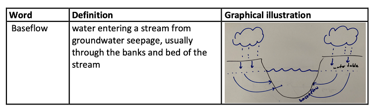
Teachers can provide graphical illustrations to show the meaning of terms to support literacy in the pre-teaching of terminology. This is used as a quick reference to help students with the complexities of a new vocabulary. Providing an illustrative glossary is a useful resource.
During learning sequences, geography students can make use of a strategy similar to Stants' (2013) parts card, which is demonstrated in
the Science section of the toolkit to introduce scientific language by teaching morphemes. As students read texts or discuss concepts in geography, they are encouraged to create their own illustrative glossary for new vocabulary. This involves them generating meanings (either through reading or discussion) and drawing a diagram to demonstrate their understanding, as seen below for the term 'baseflow' (VCGGC099,
VCGGK106).
Activity idea - The illustrative glossaries can also be used to build knowledge or reflect on learning if the definitions, examples and photographs are provided jumbled. Students are then encouraged to match words and definitions with illustrations.
Base words and suffixes
Geography texts often use suffixes to form technical terms that are more abstract, generalised expressions (Shanahan & Shanahan, 2014). For instance, a student might read 'Urbanisation occurs when people move from rural areas to urban areas'. In this case, the adjective 'urban' has been turned into the noun 'urbanisation.' This process of creating nouns from other word groups is called nominalisation. Nominalisation is a key feature of academic written texts.
The nominalisation of urban, though, is complex and involves two steps:
- urban is turned into the verb, 'urbanise', by adding the suffix [-ise]. Urbanise means to make urban.
- urbanise is turned into the noun, 'urbanisation', but adding the suffix [-ation]. Urbanisation is the process of making things more urban.
In Geography, verb base words might be transformed in the following ways:
- adding noun-forming suffixes such as [-ion], [-ity], and [-ment]. For example, when [-ion] is added to the end of the verb
produce, the nominalised form is
production.
- creating a gerund (by adding the [-ing] suffix). For example, weather can be nominalised to weathering.
pollute
| -ion
| pollution
|
active
| -ity
| activity
|
manage
| -ment
| management
|
transport
| -ation
| transportation
|
mine
| -ing
| mining
|
Teaching students explicitly about the word parts in geographical terms can support students to identify the meaning embedded in them. It also enables students to read, interpret and create geographic texts, and to write in a more sophisticated, technical and abstract manner.
One way to teach students to use different word forms of geographical terms is outlined below, together with examples.
- Introduce students to 'base' words and suffixes in Geography. Show students the examples in the table above. Instruct students to add new terms to the tables as they learn them.
- As new 'base words' are learned, ask students to add them to the examples in the tables.
- Instruct students to write two sentences with one sentence using the geographic 'base' word (i.e. verb) and the other sentence using the newly nominalised form (i.e. a noun).
Example from a Year 7 or 8 class about migration (VCGGC099,
VCGGK124)
Sentence 1: People
migrate to Australia for many different reasons.
Sentence 2: There are many reasons for
migration.
Later, when students are writing more extended texts, they can refer back to the ways in which words can be changed, encouraging the use of normalised forms.
Directed activities related to text (DARTs)
Beyond learning basic vocabulary, directed activities related to text (DARTs) help students read geographical texts more closely and effectively (Roberts, 2013). DARTs are structured activities designed by teachers to help students reconstruct a text in a different form (usually graphically) e.g. in a diagram or a table. This improves their understanding of the meaning of the text. There are two main types of reconstruction DARTs:
- sequencing text
- diagram completion.
Sequencing text
Sequencing text strategies are suitable for texts which describe processes, changes over time, and/or solutions. The teacher designs a task to have students put pieces of a text that have been jumbled into the correct sequence. The teacher also introduces students to the use of connectives (see table below) that can assist students with the sequencing of processes and events.
|
Adding information
|
and, also, besides, further, furthermore, too, moreover, in addition, equally, of equal importance, apart from that, similarly, in the same way, then
|
|
Indicating time
|
next, after a while, finally, subsequently, then, previously, thereafter, after a short time, meanwhile, in the meantime, at the same time, before that, at this point, until then
|
|
Sequencing ideas
|
first, second, (etc.), finally, next, then, from here on, to begin with, last of all, after, before, in summary, to sum up, in short, in conclusion, to conclude, briefly
|
|
Clarifying
|
in other words, for example, to illustrate, for instance, to be specific, to be more precise, such as, that is, furthermore, in particular, namely
|
|
Showing cause/result
|
as a result, hence, so, accordingly, as a consequence, consequently, thus, therefore, for this reason, because of this, in that case
|
|
Condition/concession
|
in contrast, conversely, however, still, nevertheless, nonetheless, yet, and yet, on the other hand, on the contrary, or, in spite of this, actually, even so, at least
|
(adapted from Derewianka, 2011, pp. 153-4)
The following is an example of a DART text sequencing activity completed by a Year 8 student studying landscapes (VCGGC099,
VCGGK116,
VCGGK117). Students are presented with five paragraphs of jumbled text describing the formation of sand dunes (left). As they work in pairs to put these in sequence, they also highlight the connectives that have aided them in the reading and reconstruction and resequencing of the text (right).
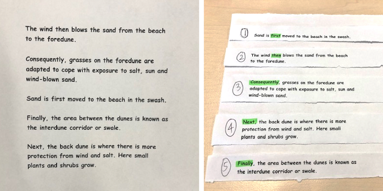
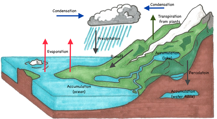
Diagram completion
The use of diagram completion is suitable for texts which describe the structure of features and their parts. The following is an example of a DART diagram completed by a Year 7 or 8 student studying the water cycle (VCGGC099,
VCGGK106).
- Students are presented with a text, together with a diagram with all the labelling removed. For example, about the hydrological cycle.
- Student read the text and highlight key terms, processes and ideas. They may also annotate the text.
Depending on student ability, the teacher may model the reading of the text or use shared reading.
Water heated by the sun
evaporates from soil and water surfaces to form water vapour. Plants also release water vapour through
transpiration. As water vapour rises into the atmosphere, it cools and
condenses to form water droplets. These droplets form clouds and fog. When the clouds become heavy, they fall to the Earth's surface as
precipitation, which can be rain, hail, sleet or snow. Precipitation that falls on land will may remain on the Earth's surface and form
runoff, eventually
accumulating in a collection of water, such as a river, lake or ocean. Precipitation may also seep, or
percolate, into the ground. Percolated water is then either taken up by plants or joins the water table. The hydrologic cycle then continues.
- Students use the annotated text to label or annotate the diagram correctly, based on their careful reading of the text.