This focus idea is explored through:
Contrasting student and scientific views
Student everyday experiences
 Understanding what lies beneath the surface of the Earth is particularly difficult for students because it is beyond their direct observational experience. While students will have seen images of erupting volcanoes and be aware of earthquakes, the idea that rocks and continents are constantly moving as part of enormous but relatively thin
tectonic plates is a very demanding one as it creates a substantial mismatch with what we are able to see. This mismatch becomes even more extreme with the issue of time given that the time periods involved in the movement of tectonic plates are huge; way beyond anything students have encountered before. This is in total contrast with the extremely short (in geological terms) time involved in the ideas they will have of earthquakes and volcanic eruptions.
Understanding what lies beneath the surface of the Earth is particularly difficult for students because it is beyond their direct observational experience. While students will have seen images of erupting volcanoes and be aware of earthquakes, the idea that rocks and continents are constantly moving as part of enormous but relatively thin
tectonic plates is a very demanding one as it creates a substantial mismatch with what we are able to see. This mismatch becomes even more extreme with the issue of time given that the time periods involved in the movement of tectonic plates are huge; way beyond anything students have encountered before. This is in total contrast with the extremely short (in geological terms) time involved in the ideas they will have of earthquakes and volcanic eruptions.
 These ideas are also related to the focus idea
Geological time.
These ideas are also related to the focus idea
Geological time.
Views held by students include:
- soil can extend several kilometres under the Earth's surface
- lava in volcanoes comes from the centre of the Earth, it is pushed up to the surface
- landforms such as mountains, seas and continents do not change. They have always been where they are now
- under the Earth there are central fires, magnets and underground seas
- the crust floats on a sea of liquid rock, i.e. the Earth contains only molten rock except for the solid crust.
Research: Blake (2005), Dal (2006), Philips (1991)
Students often believe that earthquakes occur when the sun heats the Earth's surface causing it to expand and crack while others believe that earthquakes erupt.
Apart from believing that the lava comes from the centre of the Earth, other views about volcanoes include:
- volcanoes are not found in cold climates, only in warm areas; they do not have snow on them
- volcanoes become active and erupt when they become too full of lava.
Research: Dove (1998), Bezzi & Happs (1994)
When students are asked to draw a sketch of what lies beneath their feet they frequently draw a diagram similar to the example shown below, which has dirt, bones, roots and rocks below the surface with the possibility of some layers including lava.
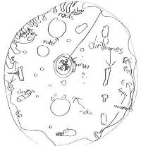
Research: Skamp (2004)
Scientific view
It is about 6,400 km from the Earth’s surface to its centre. For convenience, the distances below are expressed as a percentage of this figure, as well as given directly. Evidence from earthquakes, volcanoes and igneous rocks (which sometimes contain fragments of what is thought to be upper mantle material) suggest that the Earth is made up of four principal layers.
The
crust, which is solid, can be as thin as 6km in some oceanic areas and generally around 35 km (about 0.5%) thick in continental areas. Soil, where present, forms a very thin layer at the most metres thick. The crust rarely exceeds 50 km in thickness.
The
mantle is made of rock material that is more dense than the crust, is around 2900 km (0.5 - 46%) thick and is predominantly solid although localised melting can occur because of high pressures. It can show plastic flow in the same way that ice ‘flows’ in glaciers. The consequences of this flow are tectonic plate movements and resulting earthquakes and volcanoes.
The
outer core extends from 2,900-5,150 km (46% - 81%) below the surface. It is liquid and made predominantly of iron, a very much denser material than the rock materials in the mantle and crust, with small amounts of other elements. The Earth's magnetic field is a result of convection currents in this outer iron core.
The dense
inner core extends from 5,150-6,370 km (the remaining 19%) below the Earth's surface. It is solid and made of almost pure iron.
The molten rock that is part of volcanic eruptions flows from the lower crust and upper part of the mantle. It usually originates from no more than 100km (1.5%) below the Earth's surface. Material from the core never reaches the surface.
The crust and the top layer of the mantle down to a depth of around 100 km (1.5%) are called the lithosphere. The lithosphere lithosphere is solid and rigid. A network of 14 major and a number of minor tectonic plates make up this layer. These solid plates carry both continents and oceans, and move on the top part of the mantle. Heat and very high pressures mean that the rocks in this top part of the mantle can flow slowly, but, like the ice in glaciers, it would be incorrect to say they are liquid.
See websites listed in
Further resources to extend your understanding.
Critical teaching ideas
- Plate tectonics is a very good example of a ‘big’ scientific idea that is useful because it explains so many Earth related phenomena.
- The Earth's surface consists of a number of huge plates up to 100km thick which move at speeds between 2 and 15 cm a year.
- Volcanoes and earthquakes are largely the consequence of plate movement and often occur at the edges of these plates.
- Earth scientists have proposed that the Earth is constructed of layers. This model is derived from evidence from earthquake waves, volcanoes, rock types and the Earth's magnetic field.
 Explore the relationships between ideas about the structure of the Earth in the
Concept Development Maps – Changes in the Earth’s Surface and Plate Tectonics.
Explore the relationships between ideas about the structure of the Earth in the
Concept Development Maps – Changes in the Earth’s Surface and Plate Tectonics.
An understanding of the layered nature of the Earth is central to understanding plate tectonics and earth science. Geological processes such as the movement of the continents, mountain formation, the worldwide distribution of earthquakes and volcanoes and aspects of evolution (including the production of Australia's unique flora and fauna and the distribution of fossils) all depend on an understanding of plate tectonics – the very slow movement of solid continental plates across a plastic lower layer.
This topic also allows students to explore how scientists construct understandings and explanations of things that they cannot directly observe – ‘How can they know?’ can be an important theme for study with this context.
Although the information at the following website is not appropriate for students at this level, it is included here as a teacher resource because it provides good explanations of the ways shock waves from earthquakes are used by Earth scientists to reveal information about the size and properties of the principal Earth layers.
Research: Flick & Lederman (2006)
Teaching activities
Because students usually observe only small changes in the Earth’s surface the viewing of videos and animated websites showing dramatic land transformations alone are unlikely to change the student’s existing views. Students should be introduced to and practice using the idea that small geological changes over a human timescale will result in very dramatic changes over geological time scales.
Students’ prior views should be identified and then their understanding should be guided and developed through discussion and hands-on activities. Opportunities to make models, draw diagrams and to manipulate the models to help students explain their ideas should be provided. The construction of diagrams and of models also assists students to consider the unseen interior of the Earth as part of the whole Earth system, as opposed to their usual perspective, as an observer located on a very small region of the Earth’s surface.
Bring out students’ existing ideas
After a preliminary discussion of the size of the Earth and what could be inside, ask students in small groups to draw on large sheets of paper a circle to represent a cross-section through the Earth. Ask them to imagine a tunnel passing to the centre of the Earth from under their feet and have them describe all the things they would encounter on the way to the centre. The questions below should be discussed but not answered prior to having the students complete their posters showing the objects they think they would encounter.
Questions posed could include:
- How deep is the soil?
- Where are the first rocks?
- Where would you find lava?
- Where does lava come from?
- What's it like in the centre?
Promote reflection and clarification of existing ideas
Students can then show their posters to the class and discuss common aspects of them. It is possible that some students will have heard of terms such as the crust, mantle and the core. The posters can be kept for later reflection on how the student’s ideas may change after investigating this topic.
Challenge some existing ideas
The teacher could draw a circle with a radius of 1m to represent the Earth (scale 1m = 64000km) and ask the students to predict and draw using this scale the following:
- the Earth's deepest drill hole at Kola Peninsula, Russia, 1994 (around 2mm)
- the source of volcanic lava (around 16mm)
- the average depth of soil (much thinner than a hair)
The student’s predictions can then be discussed and the correct depths shown and contrasted with the predictions. Later, students who have researched the Earth's layers can mark in, the following features using the same scale:
- the crust (around 5mm from the surface)
- mantle (between 5mm and 450 mm from the surface)
- outer core (between 450mm and 810mm from the surface)
- inner core (the inner circle of radius about 190 mm)
Students work out part of the answers for themselves
Students could investigate how well sound waves travel through a metal fence rail compared to rails made from other materials. They could experiment with sound waves created by tapping a pencil on bench tops made from different materials. Just as the movement of sound waves in each of these objects can tell us much about the materials from which they are constructed, earthquake waves travelling through the Earth also provide evidence for the existence of geological structures that can never be seen. Encourage students to investigate how scientists develop ideas about the interior of the Earth, given that it cannot be viewed directly. Students can also investigate the causes of earthquakes and volcanoes and what they tell us about the inner structure of the Earth and present their findings using graphic organisers like Venn diagrams or concept maps (see the
Graphic Organisers).
For evidence of geological structures see the following websites:
Practise using and building the perceived usefulness of scientific models
As early as 1912, Alfred Wegener proposed a controversial theory of movement of the continents in his book 'The Origin of Continents and Oceans'. He was convinced that identical fossil evidence from different continents confirmed that many of the continents were once joined together and have since separated to drift slowly across the Earth’s surface. His initial proposal was ridiculed by most of the Earth science community for over 50 years; it was not until the cause of this continental movement was established in the 1960s that the theory became widely accepted.
Students could investigate Wegener’s proposal of continental drift and research the types of evidence that Wegener used to support his initial proposal. They could look to create a poster or PowerPoint presentation which briefly tells the story of the initial ridicule of Wegener’s theory and its final acceptance by the scientific community. Students could make a list of the many different observed phenomena that are explained by the movement of continents.
For information on Wegener’s life and his theory of continental drift see the following sites:
Research: Helman (1998)
Promote reflection on and clarification of existing ideas
Students could study a popular story like Jules Verne’s 'Journey to the Centre of the Earth' or one of the many movie adaptations inspired by the book. Students can be asked to identify the scientific inaccuracies in the story. Students can then describe their own imaginary journey into the Earth’s interior using their knowledge of correct science. Small groups of students could become experts on different zones and act as tour guides on a tour which could be constructed to scale along a corridor e.g. if 1mm = 1km, the journey is 6.4 metres long. Another useful story might be 'The Magic School Bus Inside the Earth', Cole (1987).
A similar activity along with others that could be adapted for this level are described at the website of Purdue University, Department of Earth and Atmospheric Sciences site:
Clarify and consolidate ideas for/by communication to others
Students could be supported to develop analogies for the structure of the Earth and then discuss the strengths and (importantly) the limitations of each of these. As a whole class, the students could discuss examples like the ones below. Possible similarities and differences are included but students should be encouraged to develop their own and discuss them.
| Analogy | Similarities | Differences |
|---|
The Earth is like a peach.
| The Earth is round. Compared to the total diameter of the Earth, mountains and seas are like the fuzzy skin of a peach. | The smooth skin of the peach is
unlike the actual top layer of the Earth which is broken into pieces. The flesh of a Peach does not have the fluidity (plasticity) of the mantle. The solid stone in the centre of a peach differs from Earth’s liquid outer core and its solid inner core. |
The Earth is like a hard-boiled egg that has it’s shell broken all over.
| The Earth has layers. There appear to be distinct boundaries between these layers. The egg’s thin shell, white and yolk resemble the principal layers of the Earth’s crust, mantle and core almost to scale. | Eggshell pieces do not move, whereas continental plates continue to slowly move around the surface. An egg has one inner section (yolk), whereas the Earth has a solid inner core and liquid outer core. |
The Earth is like an onion. | The Earth has a number of different layers. | An onion has many layers, whereas the Earth has only four. The Earth’s layers are made of different materials whereas all the onion layers are of the same material. The Earth’s layers are relatively much thicker than onion rings. |
Practise using and building the perceived usefulness of scientific models
Students can use a wall of the classroom for a collage to develop their ideas about plate tectonics. As students find different phenomena that can be explained by the movement of plates they add photos, diagrams, pictures and text to the collage (an interactive whiteboard could be very useful here).
Promote reflection on how students' ideas have changed
Students can be asked to look again at their original drawings of the structure of the Earth and to reflect on how their views have changed. Ask them to redraw their diagrams in the light of what they now know. Each group can re-present to the class and ask for clarifications from other class members.
Further resources
Science related interactive learning objects can be found on the
FUSE Teacher Resources page.
To access the interactive learning object below, teachers must login to FUSE and search by Learning Resource ID:
-
Tectonics Investigator – this learning object illustrates and explains the Earth’s internal structure through animations and scientific data.
Learning Resource ID: 98CFY7
-
Tectonic Boundaries – this learning object enables students to apply different tectonic forces to plate boundaries and compare the effects when plates collide, separate, or slide past each other.
Learning Resource ID: SM9XAT
-
World Wonders TV Show: Earthquake – Students can build a script about earthquakes for a television show. They help a researcher to sort facts and pictures and use a model structure, sample text and images to build an explanation.
Learning Resource ID: LDHMS4
Websites
For information about the Earth’s layers and level appropriate evidence supporting their existence see the following sites: